Utah National Parks Road Trip Itinerary

Steep canyons, rushing rivers, narrow gorges, towering hoodoos, and large arches span Utah’s rugged sandstone landscape. Hues of red, orange, pink, and white create unique geological formations. A Utah National Parks road trip is a spectacular bucket list adventure.
I’ve spent a lot of time over the past few years road-tripping and hiking through Utah’s National Parks. The striking scenery always leaves me speechless. And if you’re road-tripping solo, there are a lot of first-time-friendly solo hikes in Utah. From my top hiking recommendations to transport around the parks, here are all of my tips to help you plan the ultimate Utah National Parks road trip.
Utah National Parks Road Trip Itinerary
The Mighty 5 national parks are all located in Southern Utah within a few hours from one another. Las Vegas and Salt Lake City are the closest large airports and common starting and ending points for a Utah road trip itinerary.
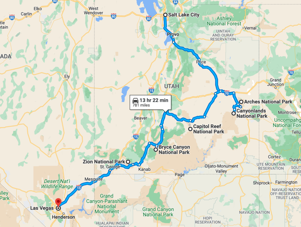
Utah National Parks Road Trip Map
Utah National Parks Road Trip: Las Vegas Start
Las Vegas is one of the best places to start your Utah national park road trip. The city is located less than 3 hours from Zion National Park.
If you start in Las Vegas, I’d recommend visiting the parks in a loop starting with Zion National Park, followed by Bryce Canyon National Park. Then head east and pass through Capitol Reef National Park on your way to Canyonlands National Park and Arches National Park.
End the trip in Las Vegas by crisscrossing along the Utah-Arizona border or head north and fly out of Salt Lake City!
Utah National Parks Road Trip: Salt Lake City Start
Salt Lake City, located in northern Utah, is another great starting point for your Utah National Parks Road Trip.
Head southwest to the city of Moab and check out Arches and Canyonland National Parks. Then head east and pass through Capitol Reef National Park on your way to Bryce Canyon National Park. With this Utah National Park itinerary, you’ll end your trip in Zion National Park.
From Zion National Park, the drive to Las Vegas is less than a 3-hour drive. It’s a bit further if you finish the trip driving I-15 north back to Salt Lake City.
Best Time of Year for a Utah National Parks Road Trip
The Utah National Parks are open year-round, weather permitting. They all have something to offer in every season, however, spring and fall have the best weather while conditions in the summer and winter are hit or miss.
Because these parks are located in the desert, temperatures can differ up to 40 degrees from daytime to nighttime. Therefore, packing layers is essential.
Spring
Spring is one of the best times of year to go on a national parks road trip in Utah. With wildflower blooms and average temperatures from 50 to 80 degrees Fahrenheit, the comfortable weather is great for hiking.
March to May offers the best weather, however, parks get crowded on weekends, especially after Memorial Day. Try to visit on weekdays if possible.
Summer
Summers in southern Utah are very hot, sometimes unbearable. The parks are packed with families on summer vacation and it’s often hard to find parking spots.
Unless it’s an unusually cool summer, try to avoid visiting then. If you already have a summer trip planned, start hikes early at sunrise before the heat of the day sets in and carry extra water.
Fall
Like spring, fall is also a great time to plan a Utah National Parks road trip. With moderate temperatures and fall vegetation, it’s a great time to go hiking and explore all the park highlights.
Like in the spring, the park remains crowded in the fall, so opt for weekday visits after Labor Day weekend.
Winter
Although the Utah national parks are in the desert, winters are very cold. Strong winds and heavy snow are common at high elevations. This causes temporary and seasonal road closures.
On the bright side, winters see the least traffic in the Utah national parks. If park roads are open and you’re prepared for cold temperatures, winter is a great time to visit and avoid the crowds.
However, winter storms move in quickly. I started hiking one morning in Bryce Canyon with sunny warm temperatures and by 2 pm a white-out blizzard started. Proper clothing and gear are necessary.
Utah National Park Entrance Fees
I’d highly recommend buying an America the Beautiful National Parks Pass when on your Utah National Parks road trip.
Each park has an entry fee of $20 – $35 per vehicle. However, for $80 you can purchase an America the Beautiful Pass. This pass covers the cost of access to all US national service areas.
This is by far one of the best deals you can get and great savings for your Utah National Parks road trip!
Purchase a pass online or at the entrance booth of the first park you visit on your Utah National Parks Road Trip.
Utah National Parks Road Trip Itinerary; How Many Days?
You could easily spend months exploring the mighty 5 Utah national parks but not everyone has this much time.
I’d recommend at least 10 days to visit all 5 parks. Visiting all the parks in a week is possible but you’ll spend a lot of time driving. If you have less than a week, choose 2 or 3 parks so you don’t overpack your trip.
But if you have the time, spend a few weeks exploring the national parks of Utah! Each park has so much to offer whether you enjoy a stunning hike, a scenic drive with iconic vistas, or a bumpy off-road tour.
Zion National Park
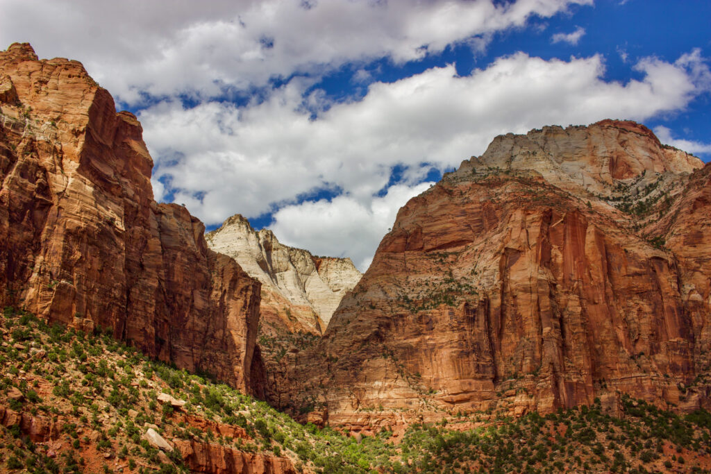
Sandstone cliffs carved by the Virgin River rise 2,000 feet above the floor of Zion Canyon. It’s no doubt why Zion National Park is the most visited park in the state and a necessary stop on your Utah National Parks road trip.
I’d recommend spending 3 – 4 days here if you can manage it. From walking along the river to hiking to high viewpoints there is so much to explore in this park. The surrounding towns also offer some of the best lodging, dining, and shopping options of all the parks.
If you have to cut your visit to Zion short, stay at least 2 days so you can enjoy a sunrise or sunset.
Zion Shuttle System & Getting Around Zion National Park
As the most visited national park in Utah, the Zion shuttle system is the most effective way to get around the park. Cars are not permitted in the canyon during the high season.
Here are some tips for navigating the Zion National Park shuttle system.
- There are 2 free shuttle lines during Zion’s high season; the Zion Canyon Line (runs through the park )and the Springdale Line (runs through the town of Springdale).
- Visitors must take the park shuttle through Zion Canyon during the high season.
- There is no shuttle during the low season in winter.
- Check the current Springdale and Zion Canyon Shuttle schedules here.
- Only visitors with reservations at Zion Lodge and Canyon Trail Rides can drive into the park with their reservation code.
- The shuttles connect at Zion Canyon Village and the Zion Canyon Visitor Center.
- You do not need reservations for either shuttle.
- The shuttle is wheelchair accessible.
- Shuttles run every 10 – 15 minutes.
- Park your car at the Zion Canyon Visitor Center if you arrive early enough.
- If you arrive later in the day, park your car at your accommodation in Springdale or in a paid parking lot.
- Do not wait to take the last shuttle out of the park. If it’s full, it’s an 8-mile walk back to the visitor center.
Zion National Park Highlights

From vistas and overlooks to full-day hikes, there are plenty of ways to spend your visit to Zion National Park. Here are some of my favorite things to do in Zion National Park.
The Narrows
2 miles out & back to 16 miles point to point, elevation varies
The Narrows is a gorge located in the narrowest part of Zion National Park. The walls on either side of the river rise over 1000 feet tall. At its widest, the gorge is over 30 feet wide but at its narrowest, sometimes less than a foot.
Hiking the Narrows is one of the most popular activities in Zion. The start of the Narrows is easily reachable via a 1-mile paved, handicap-accessible trail from the Temple of Sinawava – the last shuttle stop.
From there, wade your way up the Virgin River and turn around when you please. While the river it starts out ankle-deep, it’s not long until the water is waist-deep. Sturdy hiking poles are a must.
Adrenaline seekers can obtain permits to complete the whole Narrows. The descent starts at Chamberlin Ranch and requires canyoneering skills to reach the end at the Temple of Sinawava.
**The Narrows closes when water levels reach over 150 cubic feet per second (CFS). This often occurs following snow melts when the water flow is dangerously strong.
Angels Landing
4.5 miles out & back, 1600 foot gain
Angels Landing is the most popular and iconic viewpoint in all of Zion National Park and for good reason. It offers stunning 360-degree views looking down into Zion Canyon and of canyon walls that rise above.
With steep drop-offs and plenty of exposure, this trail is not for the faint of heart. Upon reaching Boy Scout Point, the final section of the trail entails climbing a narrow ridge to the top using metal chains for support.
If you don’t want to ascend the chains, finish your hike at Boy Scout Point. The views are stunning and similar to Angels Landing. However, if you’re comfortable climbing the chains, the accomplishment is worth it.
Due to overcrowding, permits are required to hike Angels Landing during the busy season. Check out the daily lottery here.
Emerald Pools Trail
3-mile loop, 620-foot gain

The Emerald Pools Trail is often done as a 3-mile loop starting and ending at the Zion Lodge Shuttle Stop.
Cross Zion Canyon Scenic Drive and head up the Emerald Pools Trail. Along the way, you’ll pass lower, middle, and upper pools. On your way down, continue on the Kayenta Trail which connects to the Grotto Trail, crossing over the Virgin River.
The emerald water of the pools is stunning to see as well as the Virgin River when rushing through the grasses and canyon.
Zion Canyon Overlook Trail
1 mile out & back, 190 foot gain
The Zion Canyon Overlook Trail starts just past the east entrance to the Zion-Mount Carmel Highway Tunnel.
Zion Canyon Overlook is one of the best hiking trails in Zion. It offers impressive views looking down into the canyon with the least amount of effort.
Kolob Canyon
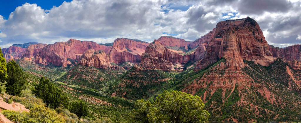
Located in the northwest part of Zion National Park, very few people visit Kolob Canyon. By vehicle, it’s only accessible at exit 40 off of I-15.
Because of this, few people visit the park. Even during the high season, Kolob Canyon is far less crowded than Zion Canyon.
Kolob Canyon has plenty to explore from short day hikes to remote backpacking trips deep in the canyons of Zion.
The Timber Creek Overlook Trail is one of my favorites in Zion National Park. Only a mile long, you’ll have impressive views looking at Kolob Canyon. This hike is also a great stretching opportunity if driving I-15 to or from Salt Lake City.
Zion National Park Lodging & Camping
There are currently 2 established campgrounds in Zion, Watchman is open year-round and Lava Point is open seasonally. Zion Lodge is the only hotel located in Zion National Park.
The town of Springdale is located just outside Zion National Park’s main entrance. It’s filled with lodging, campsites, gift shops, restaurants, cafes, and bars. Springdale is the closest town to Zion National Park.
Kanab, located on the east side of the park is a quaint wild west Utah town. Larger than Springdale, there are plenty of accommodations and camping options there.
Kanab offers many cool attractions, like Coral Pink Sand Dunes State Park and accommodations are usually cheaper than Springdale, but a further drive.
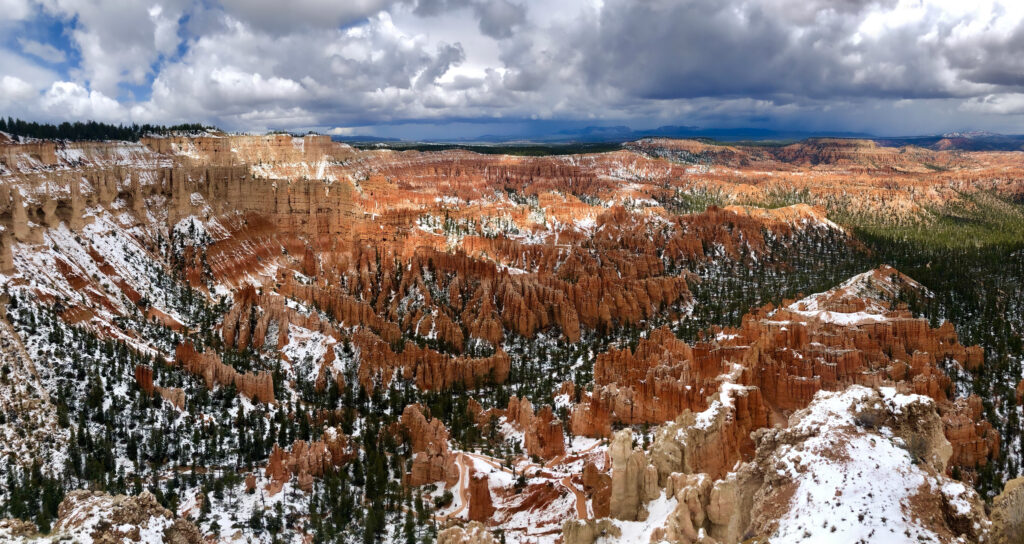
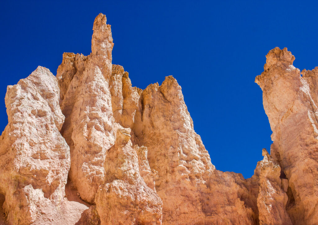
Bryce Canyon National Park
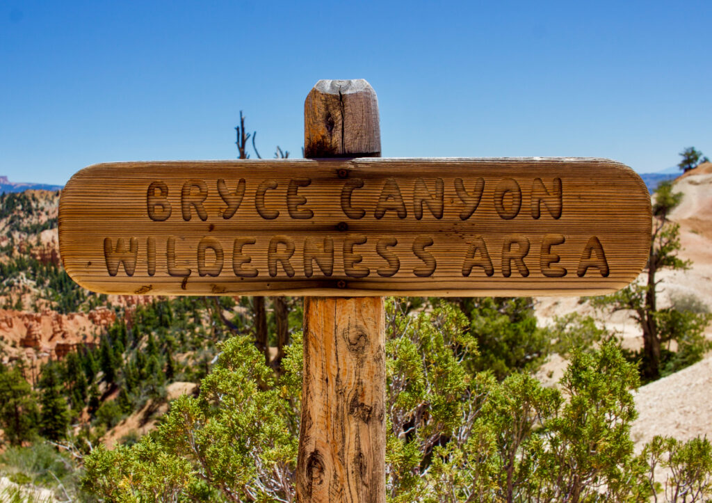
Famously known for its orange, red, and white hoodoos, spires, and amphitheaters, Bryce Canyon National Park is a must-visit on your Utah National Parks road trip. With hikes of various lengths, stunning viewpoints, and an easily accessible park shuttle, there are plenty of ways to explore the park.
I’d recommend at least 2 days in the park. While it’s possible to drive Bryce Canyon Scenic Drive in a day, if you spend a night you can enjoy a sunrise or sunset over one of the many amphitheaters and dine at one of the Western-themed bars.
Bryce Canyon Shuttle & Getting Around Bryce Canyon National Park
Bryce Canyon National Park has a 22-mile out-and-back road through the park. It’s possible to drive this road in your personal vehicle however, parking is very limited during the high season. I’d recommend taking the park shuttle.
Park your car near the visitor center, just past the Bryce Canyon entrance then hop on the shuttle at the visitor center. The shuttle runs every 10 – 15 minutes.
The free shuttle stops at all park viewpoints as well as at the main hotels in the town of Bryce. It runs during the busy season from 8 am to 6 or 8 pm depending on the time of year. Check the most up-to-date schedule here.
Bryce Canyon National Park Highlights
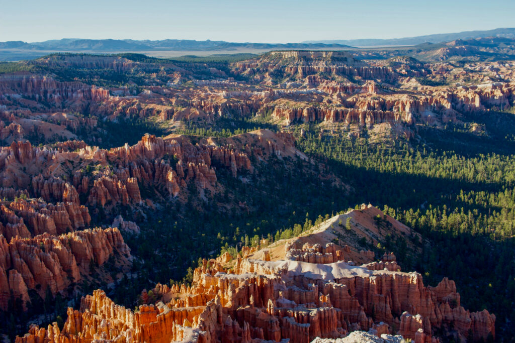
Bryce offers a variety of activities for all levels of fitness making it a perfect destination on your Utah road trip. Activities vary from scenic drives and relaxing walks to over 20 miles of backpacking trails.
Sunrise Point to Sunset Point
0.5 miles one way, 80-foot gain
Sunrise Point and Sunset Point offer incredible views looking over one of the large amphitheaters in Bryce Canyon National Park.
This short trail is great to visit at any time of day but the colors are especially stunning at sunrise and sunset.
Bryce Point
0.2 miles, viewpoint
Head out to Bryce Point, an impressive viewpoint over another one of the park’s famous amphitheaters and another excellent sunrise spot.
Fairyland Loop Trail
8-mile loop, 1500-foot gain
The Fairyland Loop Trail winds you through some of the best formations in Bryce Canyon National Park. You can start and end at Sunset Point, hike part of the Rim Trail, hike through Fairyland Point, and deep into the hoodoo canyons.
As an 8-mile hike, it’s one of the best ways to see the variety of rock formations in Bryce Canyon.
Navajo Loop Trail
1.5-mile loop, 500-foot gain
The Navajo Loop Trail offers breathtaking views starting at the top of Bryce Canyon and heading down amongst the amphitheater of hoodoos. As a short hike, this is one of the best and quickest ways you can obtain views from both above and from the base of the hoodoos.
Bryce Canyon Scenic Drive
18-mile drive, one way
The Bryce Canyon Scenic Drive is an 18-mile road (36 miles round trip) from the park entrance at the north of the park all the way to the southernmost drivable point in the park, Rainbow and Yovimpa Points.
Along the way, there are 9 vehicle pullouts at the best scenic overlooks.
The park shuttle also followed the scenic drive and stops at all the overlooks. It’s a great option when parking is limited on a busy day.
Bryce Canyon National Park Lodging & Camping

The Lodge at Bryce Canyon is the only accommodation in the park. It’s a historic structure and consists of lodges, suites, and cabins.
The North and Sunset Campgrounds are the two established campgrounds in Bryce Canyon National Park. Backcountry camping requires permits.
Located just outside the park, is the small town of Bryce with lodging, camping, and glamping accommodations.
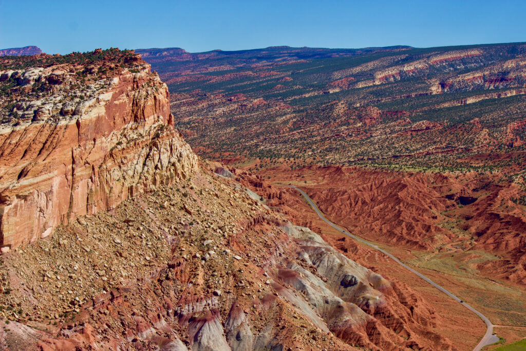
Capitol Reef National Park
Capitol Reef is central to Bryce Canyon and Arches, about 2.5 hours from each. This makes it the perfect 3rd stop on your national park road trip.
Capitol Reef is the most underrated national park in Utah, yet, it showcases impressive arches, bridges, domes, geological formations, and fault lines. As the most underrated park, it’s also the least crowded compared to the other parks.
Getting Around Capitol Reef National Park
Plan to drive yourself around Capitol Reef National Park. There are no national park shuttles, however, it’s pretty easy to get around.
Utah Route 24 is a main road that cuts through the park. The visitor center and Capitol Reef Scenic Drive are right off Route 24.
This road starts out paved then turns into a bumpy dirt road. It eventually meets with Capitol Gorge Road and Pleasant Creek Road. 4-wheel drive and high clearance is recommended for both roads.
Capitol Reef National Park Highlights
Scenic drives, a variety of hikes, and rugged back road drives are a few of the activities you can enjoy when visiting Capitol Reef National Park. Here are some of my favorite Capitol Reef things to do.
Explore Fruita
Walk around a village
Fruita is a small town located at the entrance next to the Capitol Reef Visitor Center. Visit the orchard and pick some fruit. Apples, cheers, and peaches grow seasonally here.
History lovers should check out the Gifford Homestead and Fruita Schoolhouse. There are also petroglyphs located near here.
Capitol Gorge Trail
2 – 4.5 miles out & back, 80 – 370 foot gain
The Capitol Gorge Trail is a gorgeous deep canyon. You’ll feel small walking amongst. the tall walls on either side of you. Walk a mile in to see some park highlights or continue on for a longer adventure into the impressive canyon of Capitol Reef.
Cassidy Arch Trail
3.1 miles out & back, 670 foot gain
The Cassidy Arch Trail showcases one of the most impressive, easy-to-access large arches in Capitol Reef National Park. In addition to the giant natural arch, enjoy dramatic canyon views and Capitol Reefs slide rock, a unique geological formation.
Sunset Point
0.8 miles out & back, 50-foot gain
Head to Sunset Point at sunset for impressive panoramic views of Capitol Reef National Park. Sunset Point is located right next to the Goosenecks Overlook which looks down into Sulphur Creek so it’s a great opportunity to combine the two overlooks.
The road accessing Sunset Point is located right off Utah Route-24, west of the visitor center in Fruita.
Navajo Knobs Trail
9 miles out & back, 2140 foot gain
If you’re looking for a longer trail that showcases a variety of the geology and landscapes in Capitol Reef National Park then check out the Navajo Knobs Trail. It’s the longest-maintained hiking trail in the park.
The trail begins at the Hickman Bridge Trailhead, starts up the Hickman Bridge Trail, continues on to the Rim Overlook Trail, and connects to Navajo Knobs Trail.
Along the way take in the panoramic vistas and enjoy the viewpoints at Hickman Bridge Overlook, Rim Overlook, and Navajo Knobs.
Capitol Reef National Park Lodging & Camping
Fruita Campground is the only developed campground in the park. 2 primitive campgrounds are located off of the rough roads. There are no lodges or restaurants in the Capitol Reef National Park. There are a few accommodation options located off Utah Route 24.
Canyonlands National Park
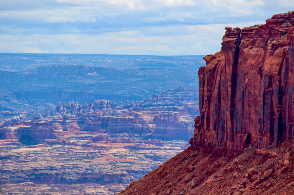
Canyonlands National Park offers a diverse landscape with panoramic overlooks above deep river-carved landscapes, towering rock pinnacles, and flat-topped mesas. As the largest national park in the state, it’s a must-visit on your Utah National Parks road trip.
You can easily spend 2 – 4 days exploring the vastness that Canyonlands offers. But if you only have 1 day, most people visit Island in the Sky.
Canyonlands National Park is divided into 3 districts all offering different opportunities in the park; Island in the Sky, The Needles, and The Maze.
Island in the Sky is the most visited part of the park located at a higher elevation. Vistas and hikes here look down into the canyons and rivers.
The Needles District features many unique rock formations rising from the ground formed by erosion and creating varying formations ranging from needles to mushroom shapes.
The Maze is the least accessible district in the park due to its remoteness. The trails and roads are rough, making it a popular spot for off-roading adventures.
Getting Around Canyonlands National Park
Like Capitol Reef, you’re on your own for transportation in Canyonlands National Park. All three districts have separate entrances located far from one another. Therefore, you should only visit one district each day.
The Island in the Sky entrance is located at the northeast entrance of the park. The Needles entrance is located in the southeast section of the park, about 2 hours from Island in the Sky.
The Maze is the hardest to access and you should only visit the Maze if you have advanced off-roading experience. You need a fully equipped high-clearance vehicle with 4-wheel drive.
It’s essential to carry emergency supplies, extra food and water, extra fuel, a spare tire, and a tire repair kit. Commercial tours are also an option in this part of the park.
Canyonlands National Park Highlights
With the 3 diverse districts, Canyonlands National Park has endless opportunities for exploration on your Utah National Parks trip.
Grand View Point Overlook & Trail
Viewpoint & 1.8 miles out & back trail, 160 foot gain
A stop at Grand View Point Overlook is a must when visiting Canyonlands National Park. Located in Island in the Sky, the panoramic vistas look down on the rest of the park, including both the Maze and Needles districts. On clear days you can even see the La Sal Mountains to the east.
You can simply drive up to the Grand View parking lot for impressive views or you can hike the Grand View Point Trail along the canyon rim. This spot is especially unique because it’s where the Green and Colorado Rivers converge.
Mesa Arch
0.7-mile loop, 90-foot gain
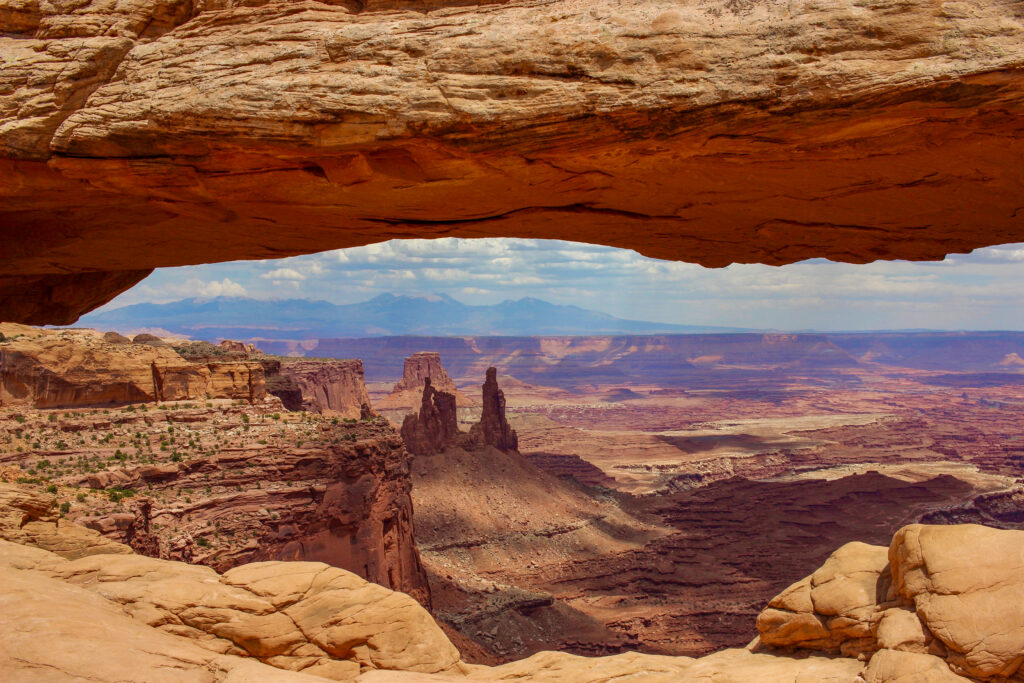
Mesa Arch is one of the most impressive and easily accessible arches in Canyonlands National Park. It’s one of my favorite short hikes in this Utah National Parks road trip itinerary.
The large arch looks out east over the deep red and orange canyons. It’s an incredible spot to watch the sunrise or go on a short walk during the day. The trail is surrounded by beautiful vegetation too.
Shafer Canyon Overlook & Shafer Canyon Trail
Viewpoint & Drive

Stand at the top of Shafer Canyon and look down at the steep, curvy road into Shafer Canyon. It’s quite bizarre to think that this road could even be constructed.
The viewpoint itself is impressive. Beyond the road, look out at the deep canyons that descend over 3000 feet.
Shafer Canyon is also a great spot for a scenic drive or mountain biking but it’s important you have the appropriate vehicle or bike and experience.
Elephant Hill Trailhead
6.4 miles out & back, 730 foot gain
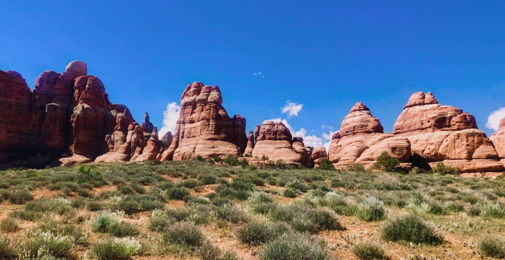
Elephant Hill is my favorite hike in the Needles district. The moderate trail offers a variety of landscapes.
Walk amongst the large “needles”, the unique rock formations that tower above you. They sort of look like giant stalagmites. You’ll also observe other unique rock formations that look like mushroom caps.
It’s easy to go off-trail in this wild landscape so I’d recommend downloading a topo map of the route when you have cell service.
Candlestick Tower Overlook
Viewpoint
Candlestick Tower is a must-see rock formation on your Utah National Parks trip. Candlestick Tower rises up high in the deep canyons and is surrounded by sweeping views.
The viewpoint is located in Island in the Sky and you can see the tower from your vehicle on the paved pullout.
Canyonlands National Park Lodging & Camping
Canyonlands has a rough and wild landscape. There are no lodges in the park. Moab is the closest city with the most lodging options.
There are two established campgrounds in Canyonlands National Park, one in Island in the Sky and the second in The Needles. Primitive and backcountry camping is the only option in the rest of the park.
Arches National Park
Right next to Canyonlands National Park is Arches National Park, famously known for its large pinnacles, fins, balanced rocks, and the densest concentration of stone arches in the world.
If you can, spend at least a day and a half or 2 days here. To avoid the crowds it’s best to visit in the early morning or late evening. The park is especially enjoyable at sunrise and sunset.
Reservations & Getting Around Arches National Park
Reservations are required to visit Arches National Park during the high season from April 1 – October 31. If you plan to enter the park between 7 am – 4 pm, you must reserve your time-entry slot online at recreation.gov.
There is no national park shuttle service in the park so plan to drive on your own. Arrive early to find parking at viewpoints and popular trailheads.
Arches National Park Highlights
When visiting Arches National Park you will see some of the most impressive freestanding sandstone arches you’ve ever seen. Drive the scenic road, get out for a hike, or just stop at viewpoints to take in the spectacular landscapes the park has to offer.
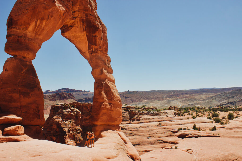
Delicate Arch
Viewpoint & hike 3.2 miles out & back, 630 foot gain
Delicate Arch is the most iconic formation in all of Arches National Park. It’s also one of the most photographable spots on a Utah National Parks road trip.
The hike out to the arch ascends the orangish-red sandstone, passing many yucca plants and prickly pear cacti before opening up to the Delicate Arch viewpoint.
From there you can walk around and under the arch. Frame a beautiful photo with the La Sal Mountains in the background or visit at nighttime to enjoy the starry desert sky.
Double Arch
0.6 miles out & back, 100-foot gain
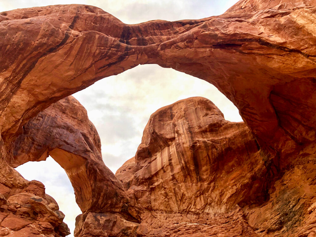
Double Arch is another iconic arch in Arches National Park. It’s a short walk out to Double Arch and offers great photo opportunities. The gently sloping sandstone into steeper sloping sandstone is a fun place to climb on.
Windows Loop
0.7-mile loop, 100-foot gain
Sharing the same parking lot as Double Arch, Windows Arch is another must-see spot on your Utah National Parks Road Trip.
The short trail offers great views from both North Arch and South Arch with an additional branch off the trail to see Turret Arch. These arches are some of the most easily accessible large arches in Arches National Park.
Balanced Rock
Viewpoint
Balanced Rock is another famous stone formation in Arches National Park. It’s a picturesque spot that also showcases a couple of other prominent rock towers next to Balanced Rock.
Arches Scenic Drive
22 miles one way, 44 out & back
Don’t miss out on Arches Scenic Drive, one of the most picturesque drives of a Utah National Parks trip.
Spend 4 -5 hours driving the paved road out and back. Stop at all the scenic viewpoints and add a hike in if you’re up for it!
Fiery Furnace
Viewpoint & hike
Fiery Furnace is a unique viewpoint along Arches Scenic Drive that’s worth a visit. The Fiery Furnace is filled with towering sandstone walls with narrow passages in between.
Hiking here is very different from the rest of the park and it’s easy to get lost. Stop by the visitor center to join a ranger-led tour or obtain a self-guided exploration permit to go out on your own.
Arches National Park Lodging & Camping
Devils Garden Campground is the only campground in Arches National Park and reservations are required ahead of time. There are no hotels in the park.
For hotels, restaurants, cafes, bars, and gift shops, drive 10 minutes south to the town of Moab for a variety of lodging options.
There are also many camping options just outside of Arches National Park ranging from glamping stays to primitive camping on public land.
Utah National Parks Road Trip Packing List
When planning your Utah National Parks Road Trip, you need a properly equipped vehicle, a variety of clothing, and enough food. Here are some packing essentials.
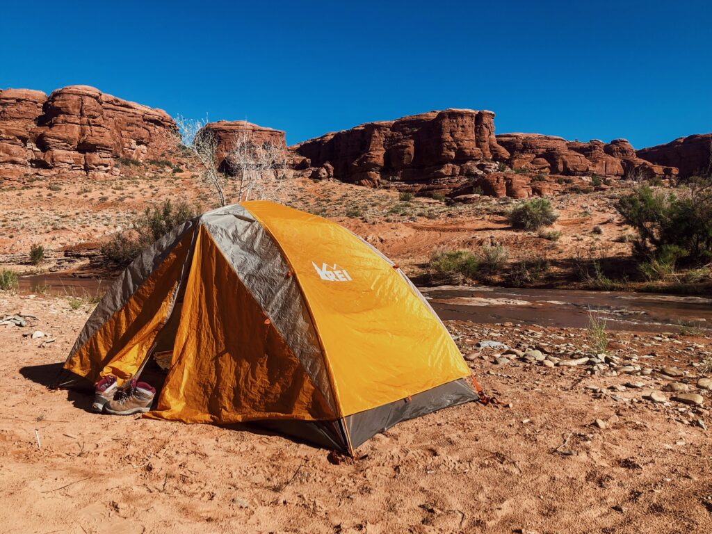
Camp & Hiking Gear
- 3-Season tent or an air mattress if you’re sleeping in your car
- 15 – 40 degree sleeping bag – depending on the time of year)
- Sleeping pad
- Headlamp
- Extra batteries
- Camp stove
- Fuel
- Lighter
- Pots & pans
- Spork
- Pocket knife
- Day pack for hiking
- Maps – both paper and off-line topo map
- Food & extra food supply
- Water & extra water supply
- Water filter
Clothing
- Layers of hiking clothing – rain jacket, puffy jacket, fleece layer, base layer, and quick-drying hiking pants – the weather changes frequently
- Hiking boots or trail runners
- Sleep clothes – clothes kept clean and separate for sleeping
- Wool socks
- Buff
- Winter hat
- Sun hat or baseball cap
- Gloves
- Sunglasses
Toiletries
- Sunblock
- Personalized first aid kit (bandaids, blister care, Neosporin, Ibuprofen, Benadryl, Tylenol, gauze, gauze pads, medical tape, medical scissors, duct tape)
- Tampons/pads
- Personal medicines
Other Can’t-Miss Stops on your Utah National Parks Road Trip
Utah’s national parks showcase some of the best landscapes the state has to offer, however, if you have a bit of extra time, check out these towns and hotspots along the Utah national parks road trip route.
Moab: Moab is a cute small city located in Southeastern Utah just outside Canyonlands and Arches National Park. As one of the largest cities along your Utah National Parks Road Trip, it’s a great spot to stop for a coffee, souvenirs, beer, or to spend a day relaxing.
Virgin River Gorge: Just north of Las Vegas on Route 15 you’ll pass through the Virgin River Gorge on your way to or from Zion. Admire the unique topography and geography at a pullout. The water flowing through is the same river that flows from high in Zion National Park.
Dead Horse Point State Park: Located just outside of Canyonlands National Park, Dead Horse Point State Park is known for its dramatic views overlooking the Colorado River.
Horseshoe Bend: If you drive the route back to Las Vegas that passes through Arizona, Horseshoe Bend is located just off of the main route. This spot is popular because the Colorado River turns 270 degrees in the deep canyon.
Lake Powell: Lake Powell is located on the Utah-Arizona border. Just south of Lake Powell is considered the start of the Grand Canyon. This large lake is part of Glen Canyon Recreation Area. It’s an enjoyable place to stop and swim or kayak.
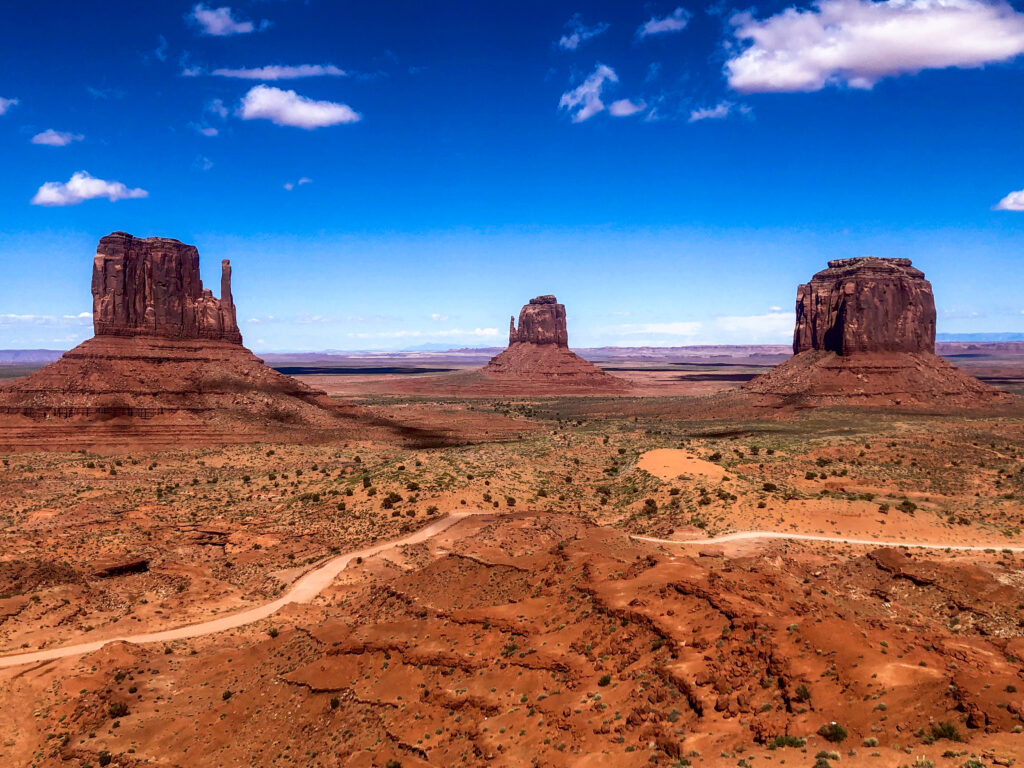
Monument Valley: Another one of the most iconic landscapes in Utah, Monument Valley sits right on the Utah-Arizona border. Spend a couple of hours driving the scenic loop. Monument Valley is located on Navajo Land so park fees are not covered by the America the Beautiful Park Pass.