Laguna de Los Tres Hike in El Chalten
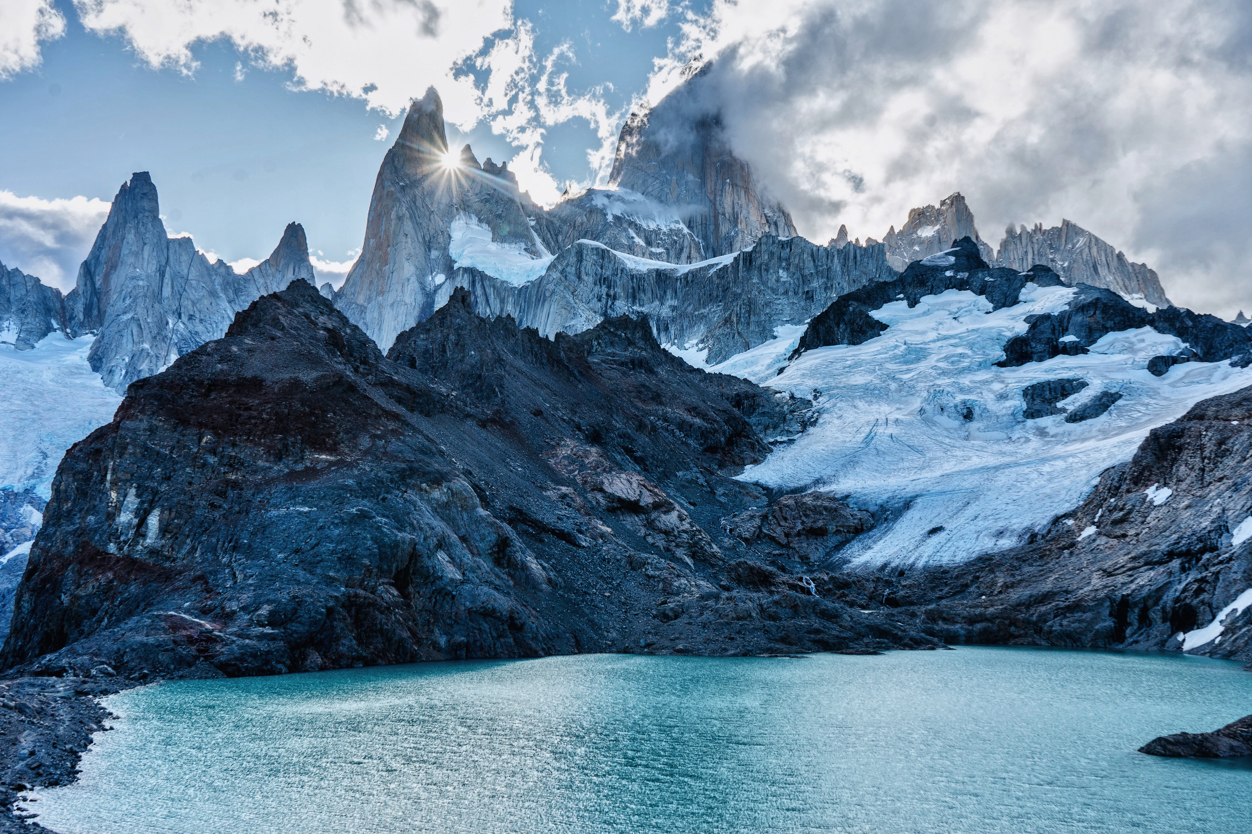
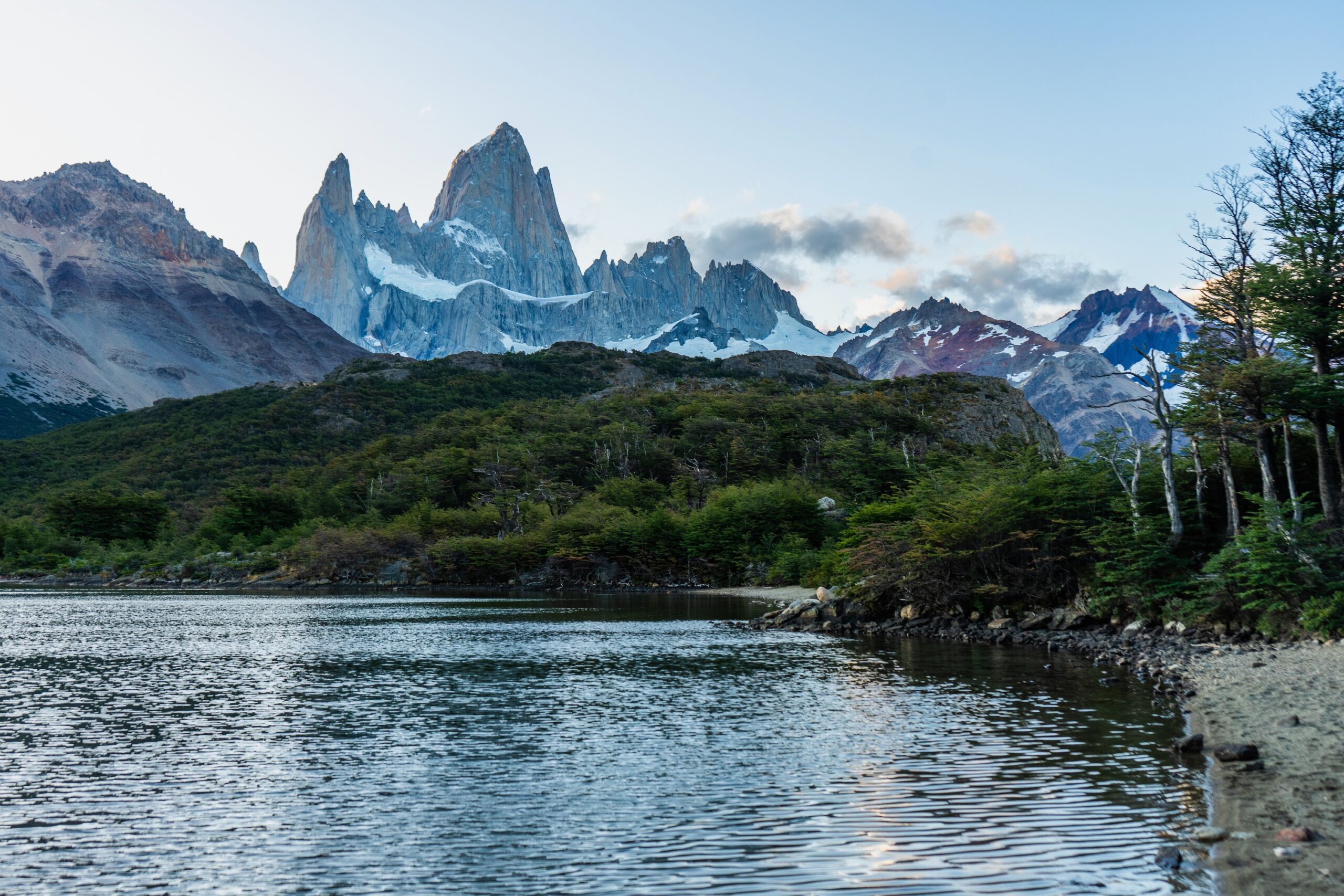
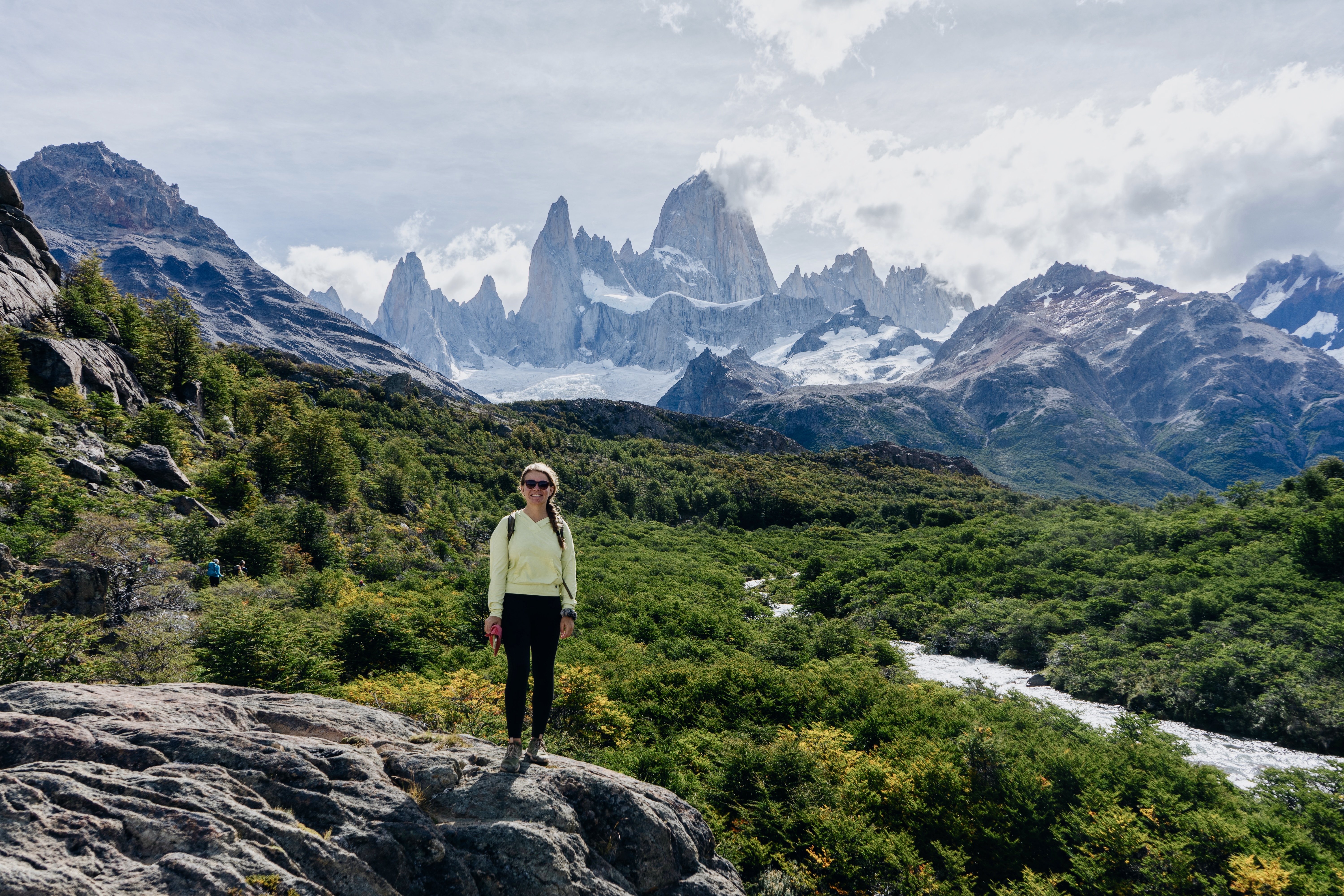
The Laguna de Los Tres hike in El Chalten is a Patagonia bucket list adventure. The iconic views of Mount Fitz Roy towering high above Los Glaciares National Park make this one of the most popular hikes in Argentinian Patagonia if not all of South America!
The hike up to Laguna de Los Tres starts in the town of El Chalten, climbs through a desert-like landscape overlooking a glacially carved valley where Las Vueltas River flows through, then climbs up into the rocky alpine. From the lake not only will you see Fitz Roy and surrounding peaks but also views of the Piedras Blancas Glacier.
Where is Laguna de Los Tres?
Located in the quaint city of El Chalten in Patagonian Argentina, Laguna de Los Tres is a large lake sitting at the base of Fitz Roy in Los Glaciares National Park.
The Laguna de Los Tres hike is commonly referred to as the Fitz Roy hike. With many interconnected trails, it’s possible to combine this hike with a few others like Laguna Sucia, Laguna Capri, and Laguna Torre.
El Chalten Weather
The weather in the mountains and down in El Chalten changes rapidly. In fact, it’s not uncommon for Mount Fitz Roy to be socked in clouds for a week at a time. But hopefully, you’ll visit when the weather is sunny.
Regardless, Patagonia and El Chalten are especially known for wind. Even down in the center of town, winds are very strong in El Chalten. Surrounded by glaciers and located near the Patagonia icefield of Los Glaciares National Park, the cold winds blow off the glaciers, through the mountains, and down into town.
Always pack layers because weather conditions are constantly changing.
While it’s possible to hike Laguna de Los Tres year-round, late spring to early fall is the best time to hike in El Chalten. September through April offer the best weather, with September and April being a bit cooler. December through February are the warmest and most popular times to visit so expect crowds on trails.
It’s still possible for storms to move in during the summer so there’s always a slight chance of snow, but more commonly rain.
Laguna de Los Tres Hike Difficulty
The Laguna de Los Tres hike is a strenuous hike. It’s about 13.7 miles, 22 km out and back. It gains about 3500 feet, 1060 m in elevation. The trail starts with a moderate ascent as you climb out of the valley and look down on Rio de Las Vueltas.
The middle of the Laguna de Los Tres hike is relatively flat but after you cross Rio Blanco, the trail becomes steeper. The final mile and a half is very steep and rocky. It’s easy to lose your footing so trekking poles are nice to have.
While it is an intense hike, it’s highly rewarding. I saw people of varying fitness levels completing the hike as both solo hikers and groups.
Some of the fastest people completed it in under 6 hours while some people took up to 12 hours. Hike your own hike and enjoy a delicious beer and pizza in El Chalten after.
Where Does the Laguna de Los Tres Trail Start?
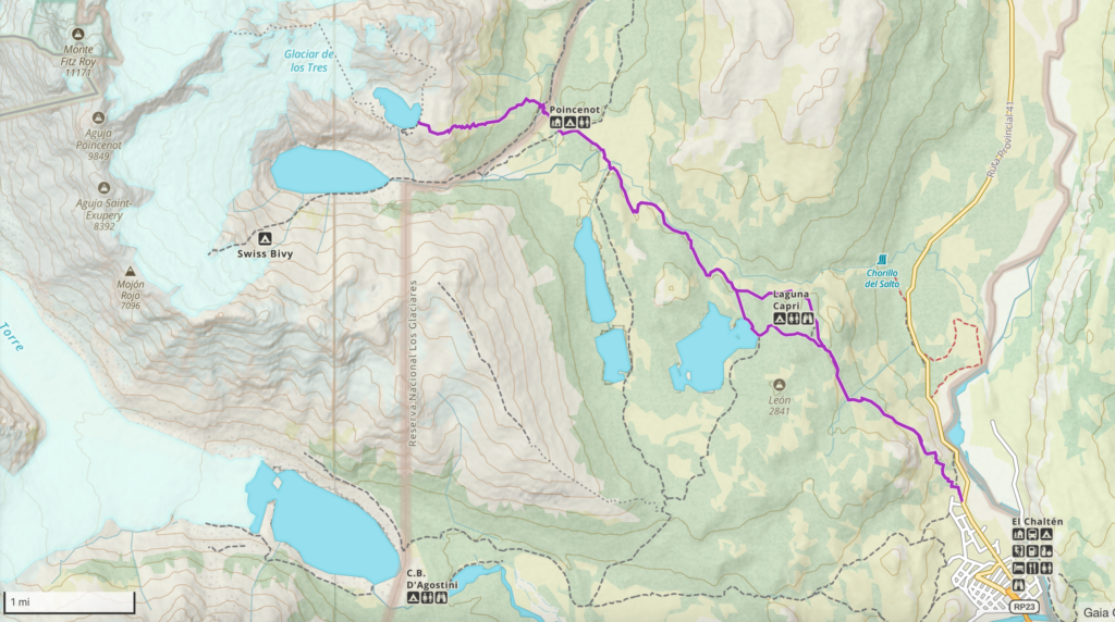
Simply enough, the trailhead for the Laguna de Los Trek hike starts right in El Chalten! Located just north of the main downtown is the trailhead: Sendero la Fitz Roy. It’s less than a 30-minute walk from all parts of El Chalten.
Most El Chalten hikes are conveniently accessible by foot, making it a lovely town to visit. Bus transport between El Calafate and El Chalten is easy and convenient.
Laguna de Los Tres Trekking Details
To really know what you’re getting into, here’s the breakdown of the trek.
Miles 0 – 2 (Kilometeres 0 – 3.2)
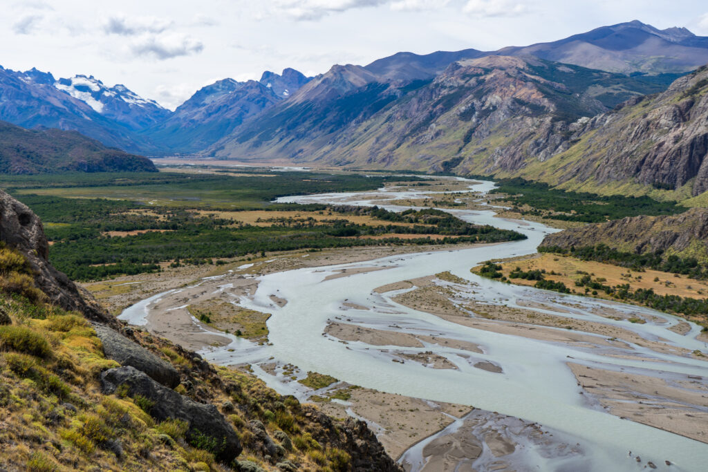
The first 2 miles of the Laguna de Los Tres hike climb up from the valley into the foothills of the mountains. Along the way, you’ll pass stunning viewpoints looking down at Rio de Los Vueltos and the surrounding distant peaks.
These first 2 miles are a moderate gain, about 1100 ft, 320 m until you reach a section where the trail flattens for a bit.
Miles 2 – 5.3 (Kilometeres 3.2 – 8.5)
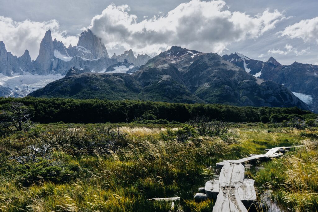
Miles 2 – 5.3 are relatively flat. There are some up-down sections along the way but the total elevation gain across those miles is only about 500 ft, 150 m. There are many stunning viewpoints of Mount Fitz Roy and Los Glaciares National Park. This stretch of the Laguna de Los Tres hike runs near Chorillo del Salto.
As you continue, you’ll eventually cross the rushing Rio Blanco. Here is where the climb begins.
Miles 5.3 – 6.6 (Kilometers 8.5 – 10.6)
These 1.5 miles, (2.4 km) are very steep. The trail gains about 1500 feet (460 m) in less than a mile and a half! It’s rough and rocky. It’s important to watch your footing. The higher you hike, the loser the rock becomes. Some people really like trekking poles here, while others use their hands to stabilize themselves on their way up.
As you get closer and closer to the viewpoint of Laguna de Los Tres, the rocks are tiny and loose. The loose rocks are very slippery even in dry conditions. Take it slow.
Miles 6.6 – 6.7 (Kilometers 10.6 – 10.8)
You’ve made it!!! Take in the stunning views of Laguna de Los Tres, Mount Fitz Roy, and the stunning landscapes in Los Glaciares National Park!
The main viewpoint looks down on the lake but it’s also possible to hike down to the water’s edge if you want a closer look!
Miles 6.7 – 8.8 (Kilometers 10.8 – 14.2)
The hike back begins. As steep and slow as the ascent was, the descent isn’t much faster. It’s especially important to watch your footing as it’s easy to slide out on your way down.
Try sidestepping as you descend through the steepest most slippery parts. Side-stepping increases the front surface area on each step giving you more stability. Take it slow and easy on your way down. And once you reach Rio Blanco, know that you’ve made it through the hardest parts!
Miles 8.8 – 10.5 (Kilometers 14.2 – 16.9)
Wooof! You made it through the toughest part! Now you’re back in the relatively flat section, with a slow, gradual descent. Enjoy the views and stroll along the way. Eventually, the path is going to fork with an option to visit Laguna Capri. Definitely check it out!
Miles 10.5 – 11.5 (Kilometers 16.9 – 18.5)
Passing by Laguna Capri adds less than a half mile to the Laguna de Los Tres hike. From Lake Capri enjoy the views of Mount Fitz Roy beyond the lake.
Miles 11.5 – 13.4 (Kilometers 18.5 – 21.6)
Now you have reached the final part of the hike; the descent through the foothills as you make your way back to El Chalten. While this descent has some steeper sections, nothing compares to the top. And before you’ll know it you’re back in El Chalten where you can grab a bite of literally anything you want to eat!
While you’re in the area, it’s also worth checking out the Laguna Torre Hike! The Laguna Torre hike is a bit easier than the Laguna de Los Tres hike but offers different views so it’s worth checking out!
Day Hike or an Overnight Hike?
While a majority of hikers complete El Chalten’s Laguna de Los Tres as a long day hike, it is also a popular overnight backpacking trip. The main reason for this is so hikers can wake up early and see the sunrise above Laguna de Los Tres. The alpenglow shines brightly off of Fitz Roy. It’s a stunning site to see.
Poincenot Campground is the main campsite along the Laguna de Los Tres hike. It’s located near Rio Blanco. It’s the perfect place to camp for a Laguna de Los Tres sunrise hike.
Laguna de Los Tres Altitude
People are always concerned about altitude when hiking to high alpine areas and for good reason! However, unlike hiking in the Alps, the US, or Canada, Patagonia actually doesn’t sit that high.
The town of El Chalten sits at 1,345 feet, 410 meters. The highest point on the trail, looking down at Laguna de Los Tres, is about 3,860 feet or 1,176 meters. While it gets windy and cold up there it’s far below the elevation where altitude sickness is a concern.
Laguna de Los Tres Hike Packing List
It’s important to prepare for anything on your Laguna de Los Tres hike! With constantly changing weather you never know what conditions you’ll encounter.
- Clothing layers – puffy jacket, fleece layer, base layer, rain layer
- Hiking boots or trail runners
- Sun hat
- Warm hat
- Day hiking backpack 18 – 30 liters
- Refillable water bottle
- Water filter
- Trekking poles
- Headlamp – even if you’re just day hiking, you might get back later than planned
- Personalized first aid kit – blister care, over-the-counter meds (Ibuprofen, Acetopmetafin, Benadryl), bandaids, gauze, medical tape, medical scissors, antibiotic ointment (like Neosporin)
- Bug spray, sunblock
- Garmin InReach Mini
- Topo Map
- Pocket Knife
- Food – lunch, snacks & what’s appropriate for your time out
- Travel Insurance
The Laguna de Los Tres hike was one of the highlights of the 6 weeks I spent in Patagonia. It offers the most iconic views of all the hikes I did in El Chalten and I already can’t wait to get back and hike it for sunrise!